A paper town is a city located on a map that exists on the map but in real life does not. Some noteworthy examples include Agloe, New York, Argleton, England, or, in this case, Beatosu and Goblu in Ohio.
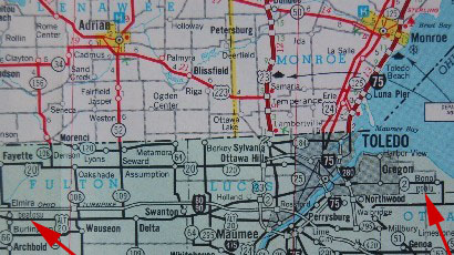
In 1978, University of Michigan alumnus and State Highway Commission Chairman Peter Fletcher was ordered to make an official Michigan state map. Fletcher had a “sly sense of humor,” so he ordered that two fake cities, Beatosu and Goblu, be included on the map. The cities’ names were puns on the Michigan-Ohio State rivalry (“Beat OSU” and “Go blue!” were the true names). Beatosu was located in way northwest central Ohio, whereas Goblu was located just east of Toledo. Of course, there was a way to tell they were fakes, because the cities’ names were in lowercase, whereas each city’s other name was capitalized. Here’s the proof, indicated by the red arrows:
The maps then became collector’s items because they appeared in the 1978-79 map and only in that map. It was even used as a good-luck charm for the Wolverines (Michigan U’s mascot) that year; they beat OSU 14-3!
In 2008, Fletcher said he had the idea when one of his fellow alumni was talking about how the Mackinac Bridge’s colors were green and white, the colors of Michigan State. Fletcher said that they were in ordinance with federal highway regulations, but then he realized he had more control over the state highway map, and…
Fletcher sadly passed away in 2012.
Paper towns are used as copyright traps, since if one fake town appears on one map, it can be used as proof it was copied. So you better be careful! Now if you don’t mind me, I’m headed off to the secluded city of Beatosu, then I’ll go to Goblu, and, oh, wait…

Cool stuff. I bet those maps are expensive!Sent from my iPhone
LikeLike